The oldest virtual antiquarium in Hungary.

Sós Antikvárium
Designed and made byte558. map/Spain, Portugal put into the basket Cary, John: A New Map of the Kingdom of Portugal.London. 1801. hand colored copper engraving.size: 44x49 cm. page: 49x57 cm. intact margin. price: 79.55 EUROAz alján a hajtásnál 5 cm-es szakadás restaurálva.
At the bottom on the fold 5 cm implosion restored. | 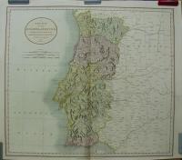 |
te1140. map/Scandinavia, Island put into the basket Seutter, Matthäus: Descriptio Nova et Accurata Scaniae, Blekingiae et Hallandiae.Augsburg. ca.1730. hand colored copper engraving.size: 47x56 cm. page: 54x63 cm. stained. price: 255.68 EURORestaurált. | 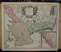 |
te592. map/Austria put into the basket Blaeu: Saltzburg Archiepiscopatus, et Carinthia Ducatus.Amsterdam. ca 1635. copper engraving.size: 39x50 cm. price: 198.86 EUROKörülvágva! Trimmed!. | 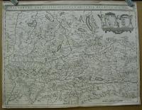 |
te1433. map/Spain, Portugal put into the basket Charte von Portugal. Nach W. Faden.Weimar. 1801. border colored copper engraving.size: 69x48 cm. page: 76x55 cm. price: 127.84 EURO | 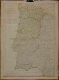 |
te955. map/Japan put into the basket Robert De Vaugondy: L'Empire Du Japon divisé en sept principales parties, et subdivisé en soixante et six Royaumes.Paris. 1750. border colored copper engraving.size: 46x52 cm. page: 54x79 cm. price: 511.36 EURO | 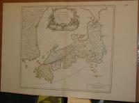 |
te959. map/United Kingdom put into the basket Robert De Vaugondy: Carte des grandes routes d'Angleterre, d'Ecosse, et d'Irlande. Par le Sr. Robert.Paris. 1757. border colored copper engraving.size: 45x56 cm. page: 54x82 cm. clean, sharp issue. intact margin. price: 198.86 EURO | 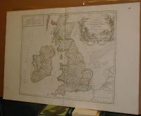 |
te1072. map/Russia put into the basket Robert De Vaugondy: SIBERIA, KAMCHATKA ,Russia.Paris. 1797. hand colored copper engraving.size: 45x59 cm. page: 56x76 cm. minimaly stained outside the picture. price: 170.45 EUROThis is a nice coloured, grand copper engraving map of Robert de Vaugondy. This map shows Siberia, the Kamchatka Peninsula as well as the adjacent areas. The map is decorated with a very decorative t... | 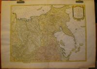 |
te1148. map/Asia put into the basket Mayer-Homann Heirs: Carte des Indes Orientales dessinée suivant les observations les plus recentes, dont le principal est tirée des cartes hydrographiques de Mr. D'Apres de Mannevillette.Nürnberg. 1748. hand colored copper engraving.size: 48x83 cm. page: 54x93 cm. stained. folded. price: 426.14 EURO | 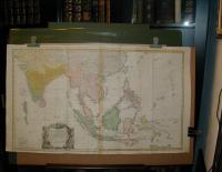 |
te957. map/Asia put into the basket Robert De Vaugondy: Carte de l'Asie dressée sur les relations les plus nouvelles principalement sur les cartes de Russie, de la Chine.Paris. 1751. border colored copper engraving.size: 45x50 cm. page: 55x78 cm. clean, sharp issue. price: 255.68 EURO | 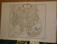 |
te1039. map/Austria put into the basket Homann, Johann Baptist: Principatus et archiepiscopatus Salisburgensis.Nürnberg. ca. 1730. hand colored copper engraving.size: 46x55 cm. page: 54x63 cm. minimaly stained outside the picture. price: 198.86 EURO | 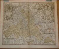 |
te149. map/Austria put into the basket Homann, Johann Baptist: Nova et accurata Carinthiae Ducatus tabula geographica.Nürnberg. ca 1730. colored copper engraving.size: 51x60 cm. page: 54x64 cm. in green paspartu. intact margin. price: 198.86 EUROAlul Klagenfurt látkép.
Fine city view at the bottom. |  |
te963. map/France put into the basket Visscher Nicolaum: Galliae feu Franciae Tabula.Amsterdam. ca. 1710. hand colored copper engraving.size: 44x53 cm. page: 51x58 cm. intact margin. price: 340.91 EURO | 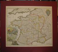 |
te1448. map/Africa put into the basket Scherer: Mappa Geographica Exhibens Religionem Catholicam Alicubi per Africam Sparsam.München. 1703. copper engraving.size: 21x33 cm. page: 27x40 cm. stained. price: 227.27 EURO | 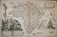 |
te29. map/Italy put into the basket Ortelius, Abraham: Oropitum (Orvieto).Antwerpen. 1588. copper engraving.size: 8x11 cm. page: 12x15 cm. in green paspartu. intact margin. price: 68.18 EURO"Epitome". | 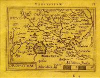 |
te28. map/Spain, Portugal put into the basket Ortelius, Abraham: Tercera Insula (Azori Island (Portugal, Acores, Azores).Antwerpen. 1588. copper engraving.size: 8x11 cm. page: 11x15 cm. in green paspartu. intact margin. price: 51.14 EURO"Epitome". | 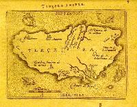 |
te11. map/France put into the basket Ortelius, Abraham: ANIOU (Anjou).Antwerpen. 1588. copper engraving.size: 9x11 cm. page: 12x15 cm. in green paspartu. intact margin. price: 51.14 EURO"Epitome". | 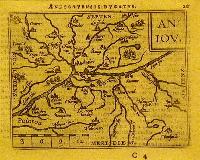 |
te24. map/France put into the basket Ortelius, Abraham: Veromandui.Antwerpen. 1588. copper engraving.size: 8x11 cm. page: 12x15 cm. in green paspartu. intact margin. price: 51.14 EURO"Epitome". | 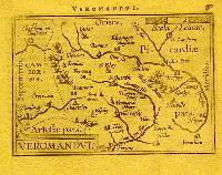 |
te20. map/Italy put into the basket Ortelius, Abraham: Perusia (Perugia).Antwerpen. 1588. copper engraving.size: 8x11 cm. page: 12x15 cm. in green paspartu. intact margin. price: 68.18 EURO"Epitome". | 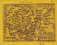 |
te1326. map/Austria put into the basket Carintia.Nürnberg. 1688. copper engraving.size: 12x14 cm. page: 15x17 cm. in claret paspartu. folded. price: 45.45 EURO | 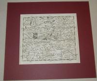 |
te1316. map/Hungary put into the basket [Mohács-Debrecen-Lippa].Nürnberg. 1688. copper engraving.size: 12x14 cm. page: 15x17 cm. in green paspartu. folded. price: 79.55 EURO | ![[Mohács-Debrecen-Lippa]](kep/th_terkep_1316_1.jpg) |
