logo

Sós Antikvárium

since 1985

Catalog   magyarul   Login

Novelty


(only in this main category)

 book | map | engraving | postcard | manuscript 

2019-08-16 friday

<--      1 2 3 4 5 6

te516.   map/United Kingdom   put into the basket

Homann Heredibus: Regnum Magnae Britanniae et Hiberniae Mappa Georgraphica.

Nürnberg. 1749. hand colored copper engraving.
size: 45x52 cm.
page: 51x58 cm.
minimaly stained outside the picture. minimal implosion on the margin.

price: 60000 FORINT

Homann Heredibus: Regnum Magnae Britanniae et Hiberniae Mappa Georgraphica

te250.   map/United Kingdom   put into the basket

Homann, Johann Baptist: Magnae Britanniae Pars Meridionale, in qua Regnum Angliae.

Nürnberg. ca. 1720. hand colored copper engraving.
size: 56x48 cm.
page: 61x53 cm.
intact margin.

price: 50000 FORINT

In the English Channel is an engraved vignette of Queen Anne in the House of Lords.
Homann, Johann Baptist: Magnae Britanniae Pars Meridionale, in qua Regnum Angliae

te1079.   map/Ireland   put into the basket

Robert De Vaugondy: L'Irlande.

Paris. ca. 1760. border colored copper engraving.
size: 22x21 cm.
page: 29x41 cm.
clean, sharp issue.

price: 45000 FORINT

Robert De Vaugondy: L'Irlande

te1067.   map/Ireland   put into the basket

Tirion, Isaak: Nieuwe Kaart van Ierland. Ireland.

Amsterdam. ca. 1740. hand colored copper engraving.
size: 32x25 cm.
page: 41x50 cm.
minimaly stained outside the picture. folded.

price: 70000 FORINT

Tirion, Isaak: Nieuwe Kaart van Ierland.  Ireland

te144.   map/United Kingdom   put into the basket

Homann Heredibus: Regionis qvae est circa Londinum (London) specialis repraesentatio geographica.

1741. colored copper engraving.
size: 50x56 cm.
page: 55x65 cm.
intact margin.

price: 90000 FORINT

At the bottom, there is a very fine London Westminster city view.
Homann Heredibus: Regionis qvae est circa Londinum (London) specialis repraesentatio geographica

te1456.   map/United Kingdom   put into the basket

Seutter, Matthaus: Tabula Novissima Accuratissima Regnorum Angliae, Scotiae, Hiberniae.

Augsburg. ca.1725. hand colored copper engraving.
size: 57x48 cm.
page: 62x54 cm.

price: 90000 FORINT

Seutter, Matthaus: Tabula Novissima Accuratissima Regnorum Angliae, Scotiae, Hiberniae

te146.   map/Scotland   put into the basket

Johan Baptist Homann: Magnae Britanni, Pars Septentrionalis Regnum Scotiae in Suas Partes et subja centes Insulas divisum Accurata Tabula ex archetypo Vischeriano desumta exhibetur imitatore.

1720. colored copper engraving.
size: 57x47 cm.
page: 63x53 cm.
in green paspartu. intact margin.

price: 70000 FORINT

stained/foltos.
Johan Baptist Homann: Magnae Britanni, Pars Septentrionalis Regnum Scotiae in Suas Partes et subja centes Insulas divisum Accurata Tabula ex archetypo Vischeriano desumta exhibetur imitatore

te321.   map/Spain, Portugal   put into the basket

Homann, Johann Baptist: Regnorum Hispaniae et Portugalliae Tabula Generalis jam nuper edita... [includes Baleric Islands].

Nürnberg. ca. 1718. hand colored copper engraving.
size: 47x55 cm.
page: 53x61 cm.
minimaly stained. intact margin.

price: 90000 FORINT

Homann, Johann Baptist: Regnorum Hispaniae et Portugalliae Tabula Generalis jam nuper edita... [includes Baleric Islands]

te1199.   map/Spain, Portugal   put into the basket

Güssefeld-Homann Heredibus: Regnorum Hispaniae et Portugalliae Tabula generalis.

Nürnberg. 1782. hand colored copper engraving.
size: 44x55 cm.
page: 52x64 cm.
stained outside the picture.

price: 90000 FORINT

Güssefeld-Homann Heredibus: Regnorum Hispaniae et Portugalliae Tabula generalis

te1043.   map/Scotland   put into the basket

Visscher Nicolaum: Exactissima Regni Scotiae Tabula.

Amsterdam. 1689. hand colored copper engraving.
size: 54x45 cm.
page: 61x53 cm.

price: 110000 FORINT

A fokhálózaton 4 mm-es lyuk van.
Homann Skócia e térkép alapján készült.
A hátlapon holland-angol nyelvű helymutató.
Irodalom: http://www.geo.ed.ac.uk:81/~rsgs/ifa/gems/MapScot.html.
Visscher Nicolaum: Exactissima Regni Scotiae Tabula

te1109.   map/Germany   put into the basket

Homann, Johann Baptist: Exactissima Palatinatus ad Rheinum.

Nürnberg. ca. 1730. hand colored copper engraving.
size: 47x56 cm.
page: 51x60 cm.
stained outside the picture. trimmed.

price: 45000 FORINT

Homann, Johann Baptist: Exactissima Palatinatus ad Rheinum

te378.   map/Germany   put into the basket

Blaeu: Oldenburg Comitatus.

Amsterdam. 1635. copper engraving.
size: 38x50 cm.
page: 41x54 cm.
in blue paspartu.

price: 60000 FORINT

Attractive map of Oldenburg, also depicting Bremen. From the French edition of Willem Blaeu's atlas "Theatrum".
Blaeu: Oldenburg Comitatus

te1105.   map/Germany   put into the basket

Lotter: Saxoniae Superioris ....Electoralis Circulus: cum adiacentibus Ducatibus et Provinciis, simulque diligentissime annotatis Postarum Cursus et Stationes.

Augsburg. 1745. hand colored copper engraving.
size: 47x56 cm.
page: 54x68 cm.

price: 45000 FORINT

Lotter: Saxoniae Superioris ....Electoralis Circulus: cum adiacentibus Ducatibus et Provinciis, simulque diligentissime annotatis Postarum Cursus et Stationes

te1112.   map/Germany   put into the basket

Sanson Nicolas: PARTIE ORIENTALE DU PALATINAT ET ESLECTORAT DU RHEIN. LES ÉVESCHÉS DE SPIRE, DE WORMES ET LE COMTÉ DE LINANGE.

Paris. 1692. border colored copper engraving.
size: 39x52 cm.
page: 51x65 cm.

price: 60000 FORINT

Sanson Nicolas: PARTIE ORIENTALE DU PALATINAT ET ESLECTORAT DU RHEIN. LES ÉVESCHÉS DE SPIRE, DE WORMES ET LE COMTÉ DE LINANGE

te379.   map/Germany   put into the basket

Blaeu: Monasteriensis Episcopatus.

Amsterdam. 1635. copper engraving.
size: 38x49 cm.
page: 42x55 cm.
in blue paspartu. minimaly stained outside the picture.

price: 70000 FORINT

Attractive map of Munster from "Theatrum Orbis Terrarum" or "Novus Atlas".
Blaeu: Monasteriensis Episcopatus

te139.   map/Germany   put into the basket

Homann, Johann Baptist: Ducatus MEKLENBURGICI Tabula Generalis continens Duc: VANDALIAE et MEKLENBURG Comitatum et Episcopatum.

Nürnberg. 1730. hand colored copper engraving.
size: 49x57 cm.
page: 52x59 cm.
intact margin.

price: 45000 FORINT

Decorative and highly detailed regional map, extending from Holstein and Lubeck in the west to Rugia and Pomerania in the east, and centered on Mecklenburg, Swerinensis, Vandalia, Rostochiense and Sta...
Homann, Johann Baptist: Ducatus MEKLENBURGICI Tabula Generalis continens Duc: VANDALIAE et MEKLENBURG Comitatum et Episcopatum

te1107.   map/Germany   put into the basket

Homann, Johann Baptist: Ducatus Brunsuicensis in tres fuos Grubenhag.

Nürnberg. ca.1730. hand colored copper engraving.
size: 48x56 cm.
page: 51x59 cm.
trimmed. implosion on the margin.

price: 25000 FORINT

Homann, Johann Baptist: Ducatus Brunsuicensis in tres fuos Grubenhag

te1106.   map/Germany   put into the basket

Homann, Johann Baptist: OSELLAE FLUMINIS TABULA SPECIALIS IN QUA ARCHIEPISCOPATUS ET ELECTORATUS TREVIRENSIS.

Nürnberg. ca. 1730. hand colored copper engraving.
size: 47x56 cm.
page: 51x59 cm.
shabby. implosion on the margin.

price: 25000 FORINT

Homann, Johann Baptist: OSELLAE FLUMINIS TABULA SPECIALIS IN QUA ARCHIEPISCOPATUS ET ELECTORATUS TREVIRENSIS

te1110.   map/Germany   put into the basket

Homann, Johann Baptist: Ducatus Iuliaci & Bergensis Tabula Geographica, simul Ducatum Cliviae & Meursiae Principatum ... Ducat. Limburgensis.

Nürnberg. ca. 1730. hand colored copper engraving.
size: 55x46 cm.
page: 59x51 cm.
damaged.

price: 35000 FORINT

Homann, Johann Baptist: Ducatus Iuliaci & Bergensis Tabula Geographica, simul Ducatum Cliviae & Meursiae Principatum ... Ducat. Limburgensis

te558.   map/Spain, Portugal   put into the basket

Cary, John: A New Map of the Kingdom of Portugal.

London. 1801. hand colored copper engraving.
size: 44x49 cm.
page: 49x57 cm.
intact margin.

price: 28000 FORINT

Az alján a hajtásnál 5 cm-es szakadás restaurálva.
At the bottom on the fold 5 cm implosion restored.
Cary, John: A New Map of the Kingdom of Portugal

te1454.   map/Scandinavia, Island   put into the basket

Merian, Mätthaus: Sedes Belli Dano. Suecici.

1667. copper engraving.
size: 31x38 cm.
page: 35x40 cm.

price: 30000 FORINT

2db 1mm lyuk.Hajtogatás nyom.
Merian, Mätthaus: Sedes Belli Dano. Suecici

te1140.   map/Scandinavia, Island   put into the basket

Seutter, Matthäus: Descriptio Nova et Accurata Scaniae, Blekingiae et Hallandiae.

Augsburg. ca.1730. hand colored copper engraving.
size: 47x56 cm.
page: 54x63 cm.
stained.

price: 90000 FORINT

Restaurált.
Seutter, Matthäus: Descriptio Nova et Accurata Scaniae, Blekingiae et Hallandiae

te261.   map/Israel, Palestine, Judaica   put into the basket

Homann (Heirs) /Harenberg/: PALAESTINA in XII. TRIBUS divisa, CUM TERRIS ADIACENTIBUS denuo revisa & copiosior reddita.

Nürnberg. 1750. hand colored copper engraving.
size: 44x51 cm.
page: 55x62 cm.
intact margin.

price: 60000 FORINT

Homann (Heirs) /Harenberg/: PALAESTINA in XII. TRIBUS divisa, CUM TERRIS ADIACENTIBUS denuo revisa & copiosior reddita

te802.   map/United Kingdom   put into the basket

Lapie: Carte des iles Britanniques comprenant L'Angleterre L'Écosse et L'Irlande.

Paris. 1851. copper engraving.
size: 52x37 cm.
page: 66x51 cm.
intact margin.

price: 18000 FORINT

Lapie: Carte des iles Britanniques comprenant L'Angleterre L'Écosse et L'Irlande

te592.   map/Austria   put into the basket

Blaeu: Saltzburg Archiepiscopatus, et Carinthia Ducatus.

Amsterdam. ca 1635. copper engraving.
size: 39x50 cm.

price: 70000 FORINT

Körülvágva! Trimmed!.
Blaeu: Saltzburg Archiepiscopatus, et Carinthia Ducatus

te1146.   map/Transylvania   put into the basket

Seutter, Matthäus: Transylvaniae Principatus.

Augsburg. 1728. hand colored copper engraving.
size: 47x55 cm.
page: 54x62 cm.
in green paspartu. minimaly stained outside the picture.

price: 120000 FORINT

Szántai/Seutter/4a.
Seutter, Matthäus: Transylvaniae Principatus

te1103.   map/Germany   put into the basket

Homann, Johann Baptist: Abbildung der Keysrl:Freyen Reichs- Wahl- und Handelsstatt Franckfurt am Mayn mit ihrem Gebiet und Gräntzen.

Nürnberg. 1715. copper engraving.
size: 47x56 cm.
page: 53x63 cm.
in claret paspartu. stained.

price: 150000 FORINT

Homann, Johann Baptist: Abbildung der Keysrl:Freyen Reichs- Wahl- und Handelsstatt Franckfurt am Mayn mit ihrem Gebiet und Gräntzen

te1433.   map/Spain, Portugal   put into the basket

Charte von Portugal. Nach W. Faden.

Weimar. 1801. border colored copper engraving.
size: 69x48 cm.
page: 76x55 cm.

price: 45000 FORINT

Charte von Portugal. Nach W. Faden

te955.   map/Japan   put into the basket

Robert De Vaugondy: L'Empire Du Japon divisé en sept principales parties, et subdivisé en soixante et six Royaumes.

Paris. 1750. border colored copper engraving.
size: 46x52 cm.
page: 54x79 cm.

price: 180000 FORINT

Robert De Vaugondy: L'Empire Du Japon divisé en sept principales parties, et subdivisé en soixante et six Royaumes

te959.   map/United Kingdom   put into the basket

Robert De Vaugondy: Carte des grandes routes d'Angleterre, d'Ecosse, et d'Irlande. Par le Sr. Robert.

Paris. 1757. border colored copper engraving.
size: 45x56 cm.
page: 54x82 cm.
clean, sharp issue. intact margin.

price: 70000 FORINT

Robert De Vaugondy: Carte des grandes routes d'Angleterre, d'Ecosse, et d'Irlande. Par le Sr. Robert

te1072.   map/Russia   put into the basket

Robert De Vaugondy: SIBERIA, KAMCHATKA ,Russia.

Paris. 1797. hand colored copper engraving.
size: 45x59 cm.
page: 56x76 cm.
minimaly stained outside the picture.

price: 60000 FORINT

This is a nice coloured, grand copper engraving map of Robert de Vaugondy. This map shows Siberia, the Kamchatka Peninsula as well as the adjacent areas. The map is decorated with a very decorative t...
Robert De Vaugondy: SIBERIA, KAMCHATKA ,Russia

te1070.   map/Germany   put into the basket

Moll, Hermann: "A new map of Germany. Hungary. Transilvania & the Suisse Cantons.

London. 1712. border colored copper engraving.
size: 59x98 cm.
page: 65x103 cm.
clean, sharp issue.

price: 160000 FORINT

Expertly restoration.
A very large and detailed map of Germany, Hungary and Switzerland. Double-page engraved map, printed on two sheets.
Moll, Hermann:

te1148.   map/Asia   put into the basket

Mayer-Homann Heirs: Carte des Indes Orientales dessinée suivant les observations les plus recentes, dont le principal est tirée des cartes hydrographiques de Mr. D'Apres de Mannevillette.

Nürnberg. 1748. hand colored copper engraving.
size: 48x83 cm.
page: 54x93 cm.
stained. folded.

price: 150000 FORINT

Mayer-Homann Heirs: Carte des Indes Orientales dessinée suivant les observations les plus recentes, dont le principal est tirée des cartes hydrographiques de Mr. D'Apres de Mannevillette

te957.   map/Asia   put into the basket

Robert De Vaugondy: Carte de l'Asie dressée sur les relations les plus nouvelles principalement sur les cartes de Russie, de la Chine.

Paris. 1751. border colored copper engraving.
size: 45x50 cm.
page: 55x78 cm.
clean, sharp issue.

price: 90000 FORINT

Robert De Vaugondy: Carte de l'Asie dressée sur les relations les plus nouvelles principalement sur les cartes de Russie, de la Chine

te1039.   map/Austria   put into the basket

Homann, Johann Baptist: Principatus et archiepiscopatus Salisburgensis.

Nürnberg. ca. 1730. hand colored copper engraving.
size: 46x55 cm.
page: 54x63 cm.
minimaly stained outside the picture.

price: 70000 FORINT

Homann, Johann Baptist: Principatus et archiepiscopatus Salisburgensis

te149.   map/Austria   put into the basket

Homann, Johann Baptist: Nova et accurata Carinthiae Ducatus tabula geographica.

Nürnberg. ca 1730. colored copper engraving.
size: 51x60 cm.
page: 54x64 cm.
in green paspartu. intact margin.

price: 70000 FORINT

Alul Klagenfurt látkép.
Fine city view at the bottom.
Homann, Johann Baptist: Nova et accurata Carinthiae Ducatus tabula geographica

te963.   map/France   put into the basket

Visscher Nicolaum: Galliae feu Franciae Tabula.

Amsterdam. ca. 1710. hand colored copper engraving.
size: 44x53 cm.
page: 51x58 cm.
intact margin.

price: 120000 FORINT

Visscher Nicolaum: Galliae feu Franciae Tabula

te1448.   map/Africa   put into the basket

Scherer: Mappa Geographica Exhibens Religionem Catholicam Alicubi per Africam Sparsam.

München. 1703. copper engraving.
size: 21x33 cm.
page: 27x40 cm.
stained.

price: 80000 FORINT

Scherer: Mappa Geographica Exhibens Religionem Catholicam Alicubi per Africam Sparsam

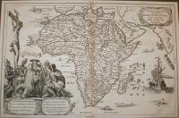
te29.   map/Italy   put into the basket

Ortelius, Abraham: Oropitum (Orvieto).

Antwerpen. 1588. copper engraving.
size: 8x11 cm.
page: 12x15 cm.
in green paspartu. intact margin.

price: 24000 FORINT

"Epitome".
Ortelius, Abraham: Oropitum (Orvieto)

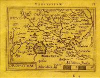
te28.   map/Spain, Portugal   put into the basket

Ortelius, Abraham: Tercera Insula (Azori Island (Portugal, Acores, Azores).

Antwerpen. 1588. copper engraving.
size: 8x11 cm.
page: 11x15 cm.
in green paspartu. intact margin.

price: 18000 FORINT

"Epitome".
Ortelius, Abraham: Tercera Insula (Azori Island (Portugal, Acores, Azores)

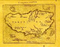
te11.   map/France   put into the basket

Ortelius, Abraham: ANIOU (Anjou).

Antwerpen. 1588. copper engraving.
size: 9x11 cm.
page: 12x15 cm.
in green paspartu. intact margin.

price: 18000 FORINT

"Epitome".
Ortelius, Abraham: ANIOU (Anjou)

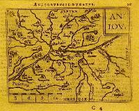
te24.   map/France   put into the basket

Ortelius, Abraham: Veromandui.

Antwerpen. 1588. copper engraving.
size: 8x11 cm.
page: 12x15 cm.
in green paspartu. intact margin.

price: 18000 FORINT

"Epitome".
Ortelius, Abraham: Veromandui

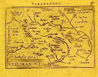
te20.   map/Italy   put into the basket

Ortelius, Abraham: Perusia (Perugia).

Antwerpen. 1588. copper engraving.
size: 8x11 cm.
page: 12x15 cm.
in green paspartu. intact margin.

price: 24000 FORINT

"Epitome".
Ortelius, Abraham: Perusia (Perugia)

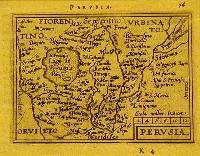
te1326.   map/Austria   put into the basket

Carintia.

Nürnberg. 1688. copper engraving.
size: 12x14 cm.
page: 15x17 cm.
in claret paspartu. folded.

price: 16000 FORINT

Carintia

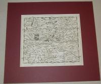
te1316.   map/Hungary   put into the basket

[Mohács-Debrecen-Lippa].

Nürnberg. 1688. copper engraving.
size: 12x14 cm.
page: 15x17 cm.
in green paspartu. folded.

price: 28000 FORINT

[Mohács-Debrecen-Lippa]

te1317.   map/Europe   put into the basket

Bessarabia ( Besarabia).

Nürnberg. 1688. copper engraving.
size: 12x14 cm.
page: 15x17 cm.
in green paspartu. folded.

price: 12000 FORINT

Moldava,
Ukraine,
Romania.
Bessarabia ( Besarabia)
<--      1 2 3 4 5 6
Sós Antikvarium Váci street 73. Budapest 1056 Hungary   top of the page