
The oldest virtual antiquarium in Hungary.
Sós Antikvárium
Designed and made byte800. map/Israel, Palestine, Judaica put into the basket Lapie: Carte de la Syrie et de L'Egypte anciennes.Paris. 1851. copper engraving.size: 53x37 cm. page: 66x50 cm. intact margin. price: 85.23 EURO | 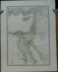 |
ko2703. book/bibliophilia, first edition put into the basket Kroeber, Dr. Hans Timotheus (Hg.): Die wunderlichen Abenteuer des Blaise Gaulard. Mit den Zeichnungen von Chodowiecki.Weimar. 1915. Gustav Kiepenheuer Verlag. 40 p. half vellum. German language.size: 19x14 cm. price: 71.02 EUROOriginal-Halbpergament,42 Blätter mit montierten Tafeln.
Numeriertes Exemplar (Nr 499 von 181 - 550 in Halbpergament hergestellten Bänden). |  |
me4456. engraving/city view/Italy city views, life pictur put into the basket Ruga, Pietro-Barboni, Pietro: ROMA.Roma, Giacomo Antonelli. 1824-27. copper engraving.size: 23x31 cm. page: 41x53 cm. price: 68.18 EURO | 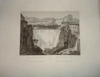 |
